


A GUIDE TO HIKING UP THE SALÈVE
3 HIKES UP THE MOUNTAIN AND WALKS ON TOP
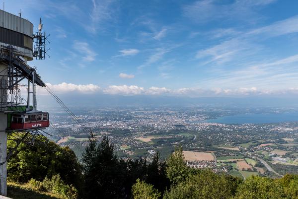
PHOTO CREDIT MAIN IMAGE: Caro Blackwell
The Salève is Geneva’s “house mountain” and a paradise for hikers, outdoor enthusiasts and sporty types who practice many different activities including toboggan, Nordic Ski, paragliding and mountain biking on its slopes.
Every week many people climb the Salève, some even do it a few times a week as a way to stay in shape. However, it’s not that easy to find your way on the mountain if you’re new to it and some of the routes are more dangerous or strenuous than others.
We asked David Viry, from the organisation Amis du Salève, who has been leading free guided walks up the mountain for many years, to provide some tips for taming the mountain.
If you’re not sure about climbing the mountain alone for the first time, why not try one of the Amis du Salève’s FREE guided tours every Sunday from Veyrier. You can also consult their website for detailed info on numerous hikes up the Salève. (More info at end of article).
WHAT IS THE SALÈVE?
Located in France with easy access from Geneva this 1380 m high mountain is quite diverse in character. Whilst the Geneva facing side has steep rocky cliffs, the East and South are characterised by gentler slopes with lots of trees. Whichever way you choose to get to the top of the Salève, you will be rewarded with magnificent views on a clear day stretching as far as the Mont Blanc and Jura.
HIKING ON TOP OF THE SALÈVE
The easiest way to access the crest of the Salève is by cable car just across the border from Veyrier. (You can also drive up the mountain by using the D41 from Collonges-Sous-Salève or Monnetier or Cruseilles). This way you’ll conserve your energy to enjoy a lovely walk on the mountain crest or you can opt to take the cable car up and to return on foot to Veyrier, which should take you roughly 1.5 hours.
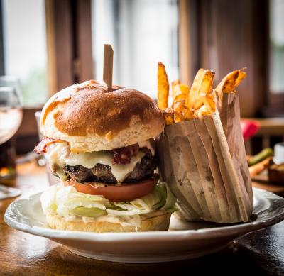
Hikes on top of the mountain, include walking from the cable car upper station to l’Observatoire in 20 minutes and then walking for hours on the crest. Enjoy a picnic or a well-earned burger at L’Observatoire Restaurant, but to be safe, book a table in advance as they do get quite full, especially on a clear and sunny day. For a review of this restaurant read this post on Taste of Savoie.
The restaurant Le Panoramique at the cable car upper station offers stunning views, but is a bit more formal and in our experience service can be hit and miss.
3 HIKES UP THE SALÈVE
 If you are more adventurous and energetic there are several more or less strenuous walks up to the summit –David highlights three hiking routes you can easily access from Geneva.
Here is his detailed and bullet-proof Salève hiking guide:
HIKING ROUTE ONE: From Veyrier
Difficulty: Quite steep, but accessible if you’re fit and particularly if you only hike up to the village of Monnetier and back down. Access the Salève from Geneva on the Veyrier side.
To get to Veyrier take bus 8, 34 or 41 and cross over the highway into France.
If you’re driving, park at the parking lot in front of Cable Car (telepherique) station (Route du Téléphérique, 74100, Etrembières, France)
NOTE: The parking area closes when the cable car stops.
After the railway on the French side turn left, walk the Chemin du Bois Meriguet, cross the bridge (over highway) into the forest, where the marked trail starts and just continue up the mountain to Monnetier – this is quite intuitive and you can simply follow the “crowds”.
The hike to Monnetier should take you around one hour and the climb is quite steep. From Monetier, follow the signs to the upper cable car station – this takes about 1.5 hours.
Another possibility is to continue hiking through Monnetier until you reach the cemetery, from the cemetery hike up to the right and then hike down to the village of Esserts-Salève. Turn right and after approximately 1 km enter the forest to your right and climb for 2 km until you arrive at a cottage. Continue straight, leaving the forest you will arrive at the upper cable car station in 20 minutes.
ROUTE TWO – Grande Gorge
 From Veyrier, if you turn right after the railway on the French side, this will allow you to access to the crest of the mountain via the « Grande-Gorge » (Big Throat).
You will need to hike parallel to the railway for about one kilometer. Then cross, on your left the bridge over the autoroute A40. After the bridge turn to the right, direction Archamps, and after 50 meters turn to the left and hike up the mountain entering the forest. After about 200 meters you will reach a stone-pit. (quarry, carrières).
Turn to the right and after 100 meters go to the left along the border of the stone-pit. After 100 meters turn right to reach the golf course, turn left to get round the golf course. Hike up left to join the path along the foot of the Saleve. Follow the path direction Collonges sous Salève. After one kilometre you will see a sign « beginning of the Grande Gorge 610m » (this should take you 45 minutes from Veyrier). Hike up to l’Observatoire – this should take you around 2h30 from Veyrier.
It is a straight climb and one of the fastest routes up. This route is not much more difficult than the others, but tiring for children and steep in some parts.
ROUTE 3 – Grotto d’Orjobet
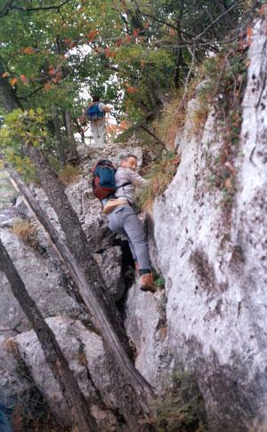
 The Grotto d’Orjobet (Cave of Orjobet) trail is one of the many access paths from the bottom. The hike ranks among “Intermediate” hikes because of the numerous passages exposed to heights which, although not very difficult, requires caution, in particular for young children.
From Collonges-sous-Salève take the road to La Croisette and park in the parking area of “Le Coin.” (You can also hike to this point from Veyrier – about one and half hours – for more info consult David’s website)
The parking area is located at 97-99 Route de Vovray 74160 Collonges-sous-Salève, France GPS: 46.132096, 6.156949
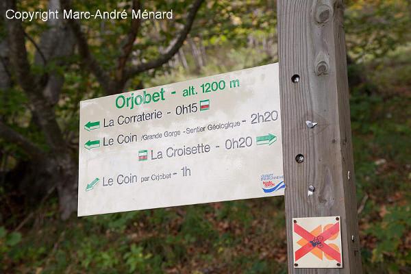
Take the path that starts at Le Coin’s car park. After a hundred meters, on the left, a first sign shows the different possible routes; Enter the forest. The path goes up in many zigzags. One hour later you arrive at the Grotto d’Orjobet where there are ladders and a cable to help you; this is at 1100m.
 Go through it. 200 meters further you have 2 choices:
1) Turn to your left (a direction sign) to join the “Trou de la Tine” and the “Corraterie” in about 10 minutes (the “Corraterie” is on a rocky shelf overlooking Geneva. The path is narrow and exposed. Avoid it if there is a strong wind. If the wind catches you, bend yourself and advance in that manner. Avoid it in winter because of the ice. Not recommended for people with vertigo. Then, just continue climbing to the top – you will reach L’Observatoire in about one hour.
2) continue straight and access, in 15 minutes, the road on the ridge of the Saleve (D41) at the cross-roads of “la Bouillette” (1214m).
From la Bouillette you can either go to the right to La Croisette (800 meters) or to the left to reach the Observatoire in one hour.
STAY SAFE ON THE SALÈVE
Do not leave the marked paths. Do not leave your children out of your sight. Have the right equipment (shoes, warm, waterpoof clothes, water, telephone) Inform yourself about weather conditions Avoid the steep paths which can be ice covered in case of frost. Watch out not to cause falling rocks onto climbers below.
Some of the paths are very dangerous during 4 months (2nd Sunday of September to 3rd Sunday of January) during hunting season.
In winter when the temperature is under 0 degrees, it is necessary to have crampons because of the ice.
It’s very risky to be caught by the night while hiking the mountain, so always start the hike early in the morning.
Also, note that when there is strong wind the cable car stops and you may have to climb down if you weren’t prepared for this.
FREE HIKES ON THE SALÈVE EVERY SUNDAY
How to join the FREE hikes on the Salève every Sunday:
Every Sunday the Les Amis du Salève group hike up the Saléve (a gradient of 800 metres, 3 hours hike-up). Meeting at 10 am at the terminus of bus No 8 at Veyrier-Douane, Route du P.as de l’Echelle 111, 1255 Veyrier (not at Veyrier-Tournettes, 100 metres from the border direction Switzerland, departure at 10h10 sharp). A responsible (excursion leader) of the Association Genevoise des Amis du Saleve (AGAS) welcomes you in all weather. No prior registration necessary. Depending on the route chosen, you will expect a 5 to 8 hours hike. Departure of the hike from the meeting point. Hiking boots (crampons in winter if ice, hat and sun protection lotion in summer), raincoat or umbrella, passport, money, picnic and something to drink as well as good health is indispensable.
MORE INFO
Site internet : http://www.rando-saleve.net .
Contact : Tel: ++41 (0) 227964133.


